
PAS 128 Surveys
PAS 128 Surveys
Survey works can be completed using cart-based or vehicle mounted GPR Systems,
depending on the site characteristics and the PAS methodology required for that particular site.

GEOTEC Surveys detect and accurately record the position, depth, route and type of buried services and utilities in line with PAS 128, detection level B, using ground penetrating radar (GPR), radio frequency detection (EML), cover lifting & topographical survey techniques.
This includes water, power, gas, telecommunications, fibre optics, drainage and other sub-surface features.
Survey works can be completed using cart-based or vehicle mounted GPR Systems, depending on the site characteristics and the PAS methodology required for that particular site.
A manhole photograph schedule and PAS 128 survey report will also accompany the final survey results drawing (in PDF and AutoCAD formats).
By allocating a quality score to each detected service, Geotec are able to demonstrate to the client, the confidence level with which this particular feature has been detected and to what accuracy tolerance. This is invaluable to the design process.
Want to know more about PAS 128 Surveys?
Want to know more about PAS128 Surveys?
Request a survey
PAS 128 Example Survey Results & Detection Levels
Our experienced surveyors are multi-trained in the on-site disciplines of Radio Frequency Services Tracing, GPR & Topographical Surveying as well as the office based functions of GPR data post processing & AutoCAD 2D & 3D.
Underground
Mapping
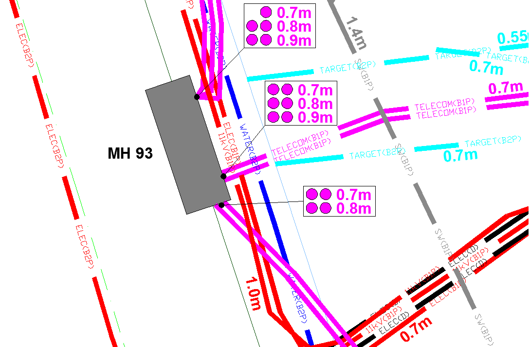
An example of a survey where several unidentified ground penetrating radar targets are present, along with confirmed buried services and utilities.
This tool also enables confirmation of the presence of metallic and conductive services that have already been detected through radio frequency detection/electromagnetic locating (RFD/EML).
GPR Surveys
Vehicle Mounted GPR Surveys
Utility Mapping / Buried Services Surveys
Service Clearance / Marking Out Surveys
PAS 128 FAQ’s
Below is a list of questions that we are asked on a regular basis about PAS 128 Utility Mapping Surveys. We have a wealth of experience so are best placed to answer them!
Why Choose GEOTEC Surveys?
Utility Mapping is our core business, our central focus, our main area of expertise – we specialise in the detection and mapping of buried services and utilities.
ITS WHAT WE DO!
Experienced—GEOTEC Surveys has a combined knowledge base spanning many years, while our surveyors have an average of 10 years of experience each.
Fully Trained—Our teams acquire both internal and external training. They also receive industry-specific training to allow them to work in Substations, on the Railway, at Water Treatment Sites, and in other high-risk environments.
Multi-Disciplined – GEOTEC Surveyors are each trained in all aspects of a PAS 128 Survey; use of Radio Frequency Detection (EML), Ground Penetrating Radar (GPR), Topographical Surveying, AutoCAD & Post-processing and evaluation of radar data.
Manufacturer independent – GEOTEC Surveys are not tied to a specific equipment provider so can choose the best tool for the job.
Nationwide – GEOTEC can meet your needs all over the UK including Scotland and Northern Ireland, so clients only need to make 1 call.
Resourceful – GEOTEC Surveys own all our equipment, however if a survey requires specialist equipment, we work with numerous providers who support us quickly and cost effectively.
Directly Employed – All staff are directly PAYE employed by GEOTEC Surveys
Ownership & Responsibility – The Lead surveyor on site is the same person who produces those survey results. This ensures that our lead surveyors have ownership of the survey from start to finish, which promotes our approach to ISO9001:2015 Quality Assurance.
Fully Insured – GEOTEC Surveys hold PI to £5m and EL / PL cover to £10m
Accredited—GEOTEC Surveys is a member of The Survey Association (TSA) and EURO GPR and holds Constructionline Gold, SSIP Acclaim, Achilles UVDB & Verify, and RISQS accreditation.
What is a PAS 128 Survey?
PAS128:2022 is the Industry Standard for Underground Utility Detection, Verification and Location.
This document offers guidance on the “best practice” methodologies and reporting for completing Underground Mapping Surveys for Buried Services and Utilities.
What does a PAS 128 Survey give you?
Ultimately, a PAS 128 Survey gives you an understanding of the level of confidence that can be attributed to the position, depth, and type of every buried service or utility shown on the survey results.
This will inform decisions about next steps and whether any additional verification or Ground Investigation is required, especially in pinch point or priority areas.
What improvements has PAS 128 made on Utility Surveys?
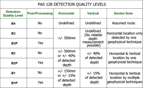
A Quality Score is provided for each detected service ranging from B1P to D
PAS 128 prescribes the grid spacings that the Ground Penetrating Radar (GPR) element of the survey should be conducted on
PAS 128 also prescribes the spacings that the Radio Frequency Detection (EML) element of the survey should adopt when (a) looking for buried services and (b) following a service trace, directly and passively
A Manhole Schedule is provided as well as an accompanying report
The provision of Statutory Record information is a prerequisite
The guidance also indicates at what intervals markings and depth readings are taken and recorded
There are numerous other benefits, but these are the main ones.
What does “P” mean?
“P” means that the Ground Penetrating Radar data which has been collected from site has been post processed in an office environment prior to the submission of survey results. Some systems allow radar data to be viewed onscreen in real time, but it is always better to evaluate the data using a suitable software programme, post survey.
Can I request a B1P / B1 Quality Score for my site survey?
No, a B1, B2, B3, B4 or D rating is provided to each individual service trace or detection in order to provide the client with a level of confidence in the accuracy and reliability that can be placed on depicted position, route, type and depth of that service.
Some services can only be detected using one of the techniques employed (for example plastic water & gas services can only be identified using Ground Penetrating Radar (GPR) and as such will have a Quality Score of B2, as a maximum.
Can GEOTEC complete a PAS 128 Survey using a Vehicle Mounted GPR survey, without Traffic Management?
No, in order to comply with PAS 128, a minimum of Radio Frequency Detection (EML) and Ground Penetrating Radar are to be utilised.
To identify the type of buried service, GEOTEC need to investigate manholes, inspection chambers, valves, gullies and other access points. To gain the appropriate accuracies, services from these access points need a radio frequency signal to be directly induced to them with the transmitter, which is followed by the receiver.
This aspect of the survey cannot be completed by using a vehicle-mounted GPR survey only, without Traffic Management, where required, to provide safe access to these access points.
We are happy to provide a quotation for a Vehicle Mounted GPR Survey and full statutory records search, which will offer a guide as to the location and depths of buried services, in high traffic sensitive areas.
How do I specify a PAS 128 Survey?
Just tell us you would like a PAS 128 Survey – the guidance dictates the methodology that needs to be adopted given the characteristics of the site
Let us know if there are any other subsurface features you are also aware of such as buried tanks, areas of voiding, cellars, old foundations etc.
Provide us with a marked-up site plan or Google maps extract showing the survey area
Forward on any topographical survey information you have
Submit any existing buried services records or stats to us
What are the implications of asking for an M4 / M4P Survey?
The guidance dictates which methodology should be adopted, based on the site and objective of the survey. If a client requests an M4P survey, then that prescribes that a 0.5m ground penetrating radar (GPR) grid is required. This will take twice as long as a 1.0m grid (unless the site is suitable for a vehicle-mounted GPR survey).
PAS 128 FAQ’s
Below is a list of questions that we are asked on a regular basis about PAS 128 Utility Mapping Surveys.
We have a wealth of experience so are best placed to answer them!
Utility Mapping is our core business, our central focus, our main area of expertise – we specialise in the detection and mapping of buried services and utilities.
ITS WHAT WE DO!
Experienced—GEOTEC Surveys has a combined knowledge base spanning many years, while our surveyors have an average of 10 years of experience each.
Fully Trained—Our teams acquire both internal and external training. They also receive industry-specific training to allow them to work in Substations, on the Railway, at Water Treatment Sites, and in other high-risk environments.
Multi-Disciplined – GEOTEC Surveyors are each trained in all aspects of a PAS 128 Survey; use of Radio Frequency Detection (EML), Ground Penetrating Radar (GPR), Topographical Surveying, AutoCAD & Post-processing and evaluation of radar data.
Manufacturer independent – GEOTEC Surveys are not tied to a specific equipment provider so can choose the best tool for the job.
Nationwide – GEOTEC can meet your needs all over the UK including Scotland and Northern Ireland, so clients only need to make 1 call.
Resourceful – GEOTEC Surveys own all our equipment, however if a survey requires specialist equipment, we work with numerous providers who support us quickly and cost effectively.
Directly Employed – All staff are directly PAYE employed by GEOTEC Surveys
Ownership & Responsibility – The Lead surveyor on site is the same person who produces those survey results. This ensures that our lead surveyors have ownership of the survey from start to finish, which promotes our approach to ISO9001:2015 Quality Assurance.
Fully Insured – GEOTEC Surveys hold PI to £5m and EL / PL cover to £10m
Accredited—GEOTEC Surveys is a member of The Survey Association (TSA) and EURO GPR and holds Constructionline Gold, SSIP Acclaim, Achilles UVDB & Verify, and RISQS accreditation.
PAS128:2022 is the Industry Standard for Underground Utility Detection, Verification and Location.
This document offers guidance on the “best practice” methodologies and reporting for completing Underground Mapping Surveys for Buried Services and Utilities.
Ultimately, a PAS 128 Survey gives you an understanding of the level of confidence that can be attributed to the position, depth, and type of every buried service or utility shown on the survey results.
This will inform decisions about next steps and whether any additional verification or Ground Investigation is required, especially in pinch point or priority areas.
A Quality Score is provided for each detected service ranging from B1P to D
PAS 128 prescribes the grid spacings that the Ground Penetrating Radar (GPR) element of the survey should be conducted on
PAS 128 also prescribes the spacings that the Radio Frequency Detection (EML) element of the survey should adopt when (a) looking for buried services and (b) following a service trace, directly and passively
A Manhole Schedule is provided as well as an accompanying report
The provision of Statutory Record information is a prerequisite
The guidance also indicates at what intervals markings and depth readings are taken and recorded
There are numerous other benefits, but these are the main ones.
“P” means that the Ground Penetrating Radar data which has been collected from site has been post processed in an office environment prior to the submission of survey results. Some systems allow radar data to be viewed onscreen in real time, but it is always better to evaluate the data using a suitable software programme, post survey.
No, a B1, B2, B3, B4 or D rating is provided to each individual service trace or detection in order to provide the client with a level of confidence in the accuracy and reliability that can be placed on depicted position, route, type and depth of that service.
Some services can only be detected using one of the techniques employed (for example plastic water & gas services can only be identified using Ground Penetrating Radar (GPR) and as such will have a Quality Score of B2, as a maximum.
No, in order to comply with PAS 128, a minimum of Radio Frequency Detection (EML) and Ground Penetrating Radar are to be utilised.
To identify the type of buried service, GEOTEC need to investigate manholes, inspection chambers, valves, gullies and other access points. To gain the appropriate accuracies, services from these access points need a radio frequency signal to be directly induced to them with the transmitter, which is followed by the receiver.
This aspect of the survey cannot be completed by using a vehicle-mounted GPR survey only, without Traffic Management, where required, to provide safe access to these access points.
We are happy to provide a quotation for a Vehicle Mounted GPR Survey and full statutory records search, which will offer a guide as to the location and depths of buried services, in high traffic sensitive areas.
Just tell us you would like a PAS 128 Survey – the guidance dictates the methodology that needs to be adopted given the characteristics of the site
Let us know if there are any other subsurface features you are also aware of such as buried tanks, areas of voiding, cellars, old foundations etc.
Provide us with a marked-up site plan or Google maps extract showing the survey area
Forward on any topographical survey information you have
Submit any existing buried services records or stats to us
The guidance dictates which methodology should be adopted, based on the site and objective of the survey. If a client requests an M4P survey, then that prescribes that a 0.5m ground penetrating radar (GPR) grid is required. This will take twice as long as a 1.0m grid (unless the site is suitable for a vehicle-mounted GPR survey).
Talk to Geotec


Follow Online
© GEOTEC SURVEYS – UNDERGROUND MAPPING


Website designed and produced by expect more – part of snap-marketing.co.uk
Website designed and produced by
expect-more.co.uk