
Utility Mapping Buried Services Surveys
Utility Mapping Buried Services Surveys
Comprehensive Detection with EML and GPR as Standard.
A GEOTEC underground utility mapping survey is one of the most comprehensive services in the industry, utilising radio frequency detection / electromagnetic locating (EML) & ground penetrating radar (GPR) as a minimum.
This also includes investigating manholes, inspections chambers, gullies, valves and other access points such as plant rooms, substations and boiler houses to directly trace the routes of known and unknown buried services.
Findings are topographically recorded, offering accurate results presented in AutoCAD 2D or 3D DWG or PDF formats.
Geotec can also carry out CCTV Surveys on drainage.
Geotec look to detect metallic and non-metallic services, including:
- Water
- Power
- Gas
- Telecommunications
- Fibre Optics
- Drainage
- Fuel & Oil
- District Heating
- Other linear targets
- GPR can also detect and map subsurface anomalies such as voids and obstructions
Want to know more about Utility Mapping Surveys?
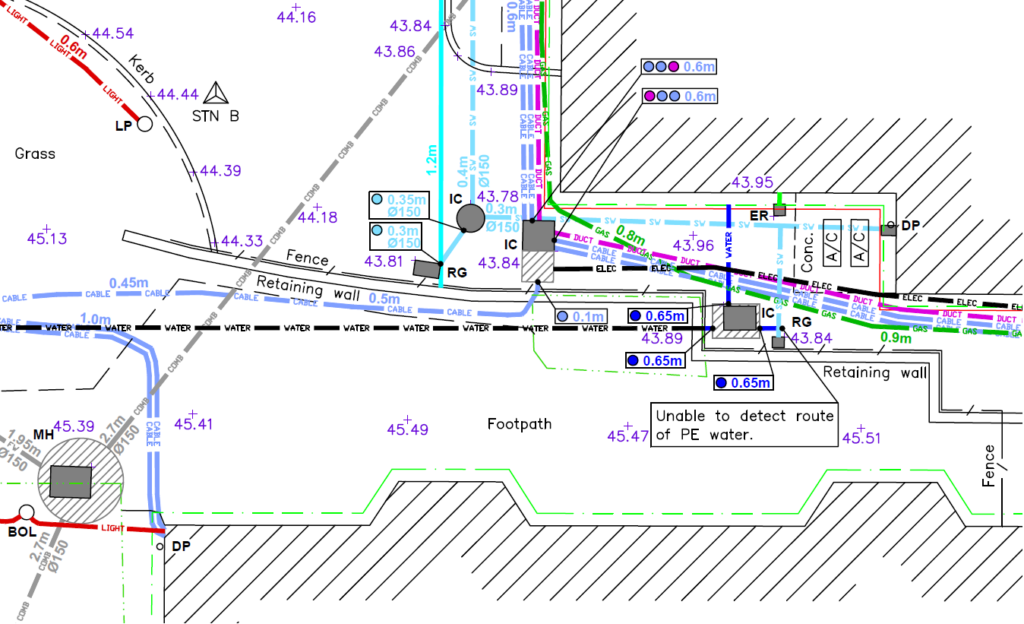
Here’s an example of the results
Underground
Mapping
An example of a survey where several unidentified ground penetrating radar targets are present, along with confirmed buried services and utilities.
This tool also enables confirmation of the presence of metallic and conductive services that have already been detected through radio frequency detection/electromagnetic locating (RFD/EML).
PAS 128 Surveys
GPR Surveys
Vehicle Mounted GPR Surveys
Service Clearance / Marking Out Surveys
Popular FAQs for Utility Mapping Buried Services Surveys
Lorem ipsum dolor sit amet, consectetur adipiscing elit. Ut elit tellus, luctus nec ullamcorper mattis, pulvinar dapibus leo.
This is an onsite survey using Radio Frequency Detection (EML) and Ground Penetrating Radar (GPR) to physically trace and map buried services and utilities.
This is completed by:
- Investigating manholes, inspection chambers, valves, gullies, and other access points to induce a radio frequency signal directly into the service (or threader for drainage/ductwork) using a transmitter box. The signal is then traced at ground level using a receiver, and the route, depth and position of the buried service are marked onto the ground surface in spray paint.
- The site is surveyed using passive radio frequency sweeps over a grid formation to identify any other conductive and metallic services, with their routes again marked on the ground in spray paint.
- We then mark out an orthogonal grid and push a ground penetrating radar (GPR) system along it, collecting data as we go. This will confirm findings we already have, as well as identify other services that have not yet been detected, such as drainage, ductwork, plastic gas and plastic water.
- These marks, together with the radar grid, are topographically recorded using an EDM alongside other hard features such as building lines, changes in surface, kerbs and boundary lines.
To meet your obligations under HSG47 and identify the locations of buried services and utilities which need avoiding, protecting or diverting. Many clients commission our services at design stage so that projects are planned in conjunction with the existing onsite buried services and utilities.
We use Radio Frequency Detection (Electro-magnetic Locating) and Ground Penetrating Radar (GPR), with topographical survey disciplines to record our findings.
We would look to locate the position, depth and, where possible, utility type for any buried services and utilities, regardless of the material of construction, and to includ,e for example, plastic pipes, fibre optic cables and ducts, communications and conductive services.
Our standard deliverable is an AutoCAD DWG file and an accompanying 2D plan view PDF output.
We can also provide an accompanying Manhole Schedule and Report, subject to the type of survey requested.
If specifically requested, we do offer CCTV surveying alongside our usual output.
In general, a utility mapping survey has a 10% tolerance in either direction, in reference to the depth of any given service. For example, a utility identified as 1m in depth will have a tolerance of 100mm in any direction. Once the threshold of the survey exceeds 2m below the ground surface, these tolerances can increase exponentially.
Some services may not be located due to many reasons and factors.
Yes, we work extensively to PAS128. This standard outlines the optimum methodology required for different types of sites and environments to achieve the best possible survey results.
GEOTEC operates nationwide, covering England, Wales, Scotland, Northern Ireland and Eire.
Talk to Geotec


Follow Online
© GEOTEC SURVEYS – UNDERGROUND MAPPING


Website designed and produced by expect more – part of snap-marketing.co.uk
Website designed and produced by
expect-more.co.uk